Townlands of Castlelyons Parish
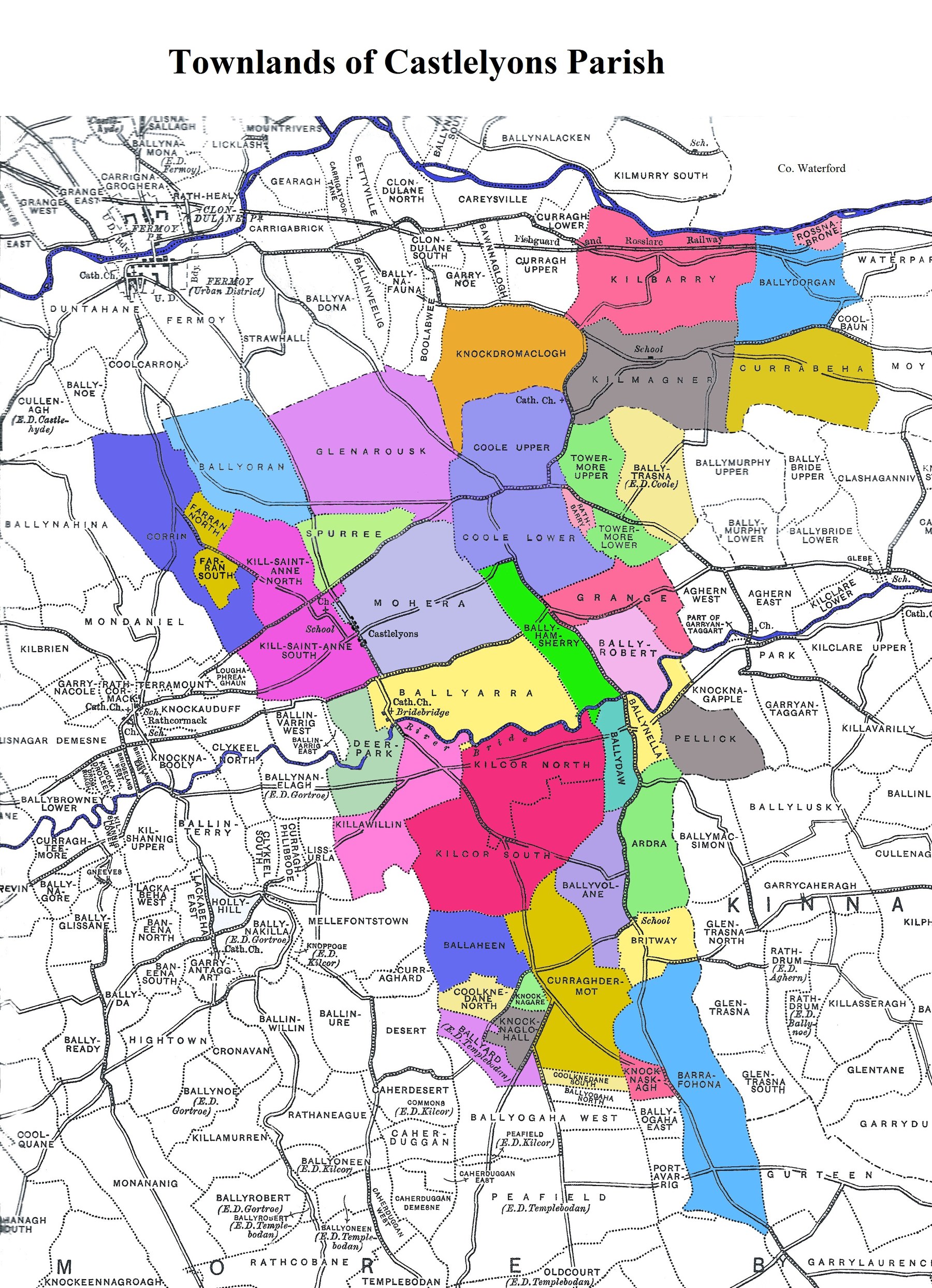
The townlands around Castlelyons tell much of the story of the parish. Their names often point to older features of the landscape, including woods, hills, rivers, roads, churches, stones, forts and places of settlement.
The local archive records both English and Irish placenames for many parts of the parish, including Castlelyons, Abbeylands, Bridebridge, Britway, Coolagown, Coole, Corrin, Kilbarry, Mohera, Pellick, Spurree and Towermore.
Castlelyons — Caisleán Ó Liatháin
Castlelyons takes its name from the castle of the O’Lehanes, one of the most recognisable landmarks in North Cork. The archive describes how important the village once was, with Main Street forming part of the old Grand Avenue leading towards the castle.
Abbeylands — Fearann na Mainistreach
Abbeylands is connected with the lands of the abbey or monastery. The archive records that Abbeylands Road ran alongside the ruins of the Abbey and is said to have served the abbey farms.
Bridebridge — Droichead na Bríde
Bridebridge means the bridge of the Bride. The bridge gave its name to the adjoining village and replaced an older ford across the river.
Britway — Bréachmhaigh
The archive notes an 1841 reference to Breach Magh, explained there as the “Field of the Wolf”. Britway is also associated with a holy well dedicated to St Bridget.
Coolagown — Cúil an Ghabhann
Coolagown is translated in the archive as the nook or corner of the blacksmith. The village has a strong association with horses and blacksmithing, reflected in local horseshoe motifs and the blacksmith sculpture in the centre of the village.
Coole — An Chúil
Coole is also linked with the idea of a corner or nook. The archive explains the name by reference to the shape of the parish boundary and records Coole Abbey as an important local historic site.
Corrin — An Carn
Corrin Hill is associated with an ancient cairn on the summit. The archive records that the hill reaches 220 metres above sea level and that the large cross on Corrin was erected in 1933.
Kilbarry — Coill an Bharraigh
Kilbarry is translated as Barry’s Wood. The archive notes Kilbarry Wood and describes two walking routes there, one approximately 2.5 km and one approximately 1.5 km.
Mohera — An Machaire
Mohera takes its name from the Irish word machaire, meaning a flat plain. The archive also records a standing stone, or gallaun/menhir, in Mohera.
Pellick — An Pheillic
Pellick lies on the eastern side of the parish, with the River Douglas forming a natural boundary. The archive records an old roadway, former river crossing points and a later footbridge used locally for many years.
Spurree — Sparraí Cloch
Spurree is described as a small townland at the northern entrance to Castlelyons village. Its name is linked in the archive with local rock outcrops visible in the surrounding fields.
Towermore — Teamhair Mhór
Towermore is translated in the archive as a great elevated place. The archive records the townland as consisting of approximately 245 acres.
This page is an introduction only. More detailed townland pages may be added over time as archive material is reviewed and checked.
This page is part of a developing local history and heritage section for Castlelyons, Coolagown, Britway and surrounding townlands. The material is being reviewed gradually from local community archive records. Please contact the website team if you can help correct, improve or add to this information.